Monday, April 13, 2015

MAPS


 Google Earth, Google Maps and GPS Rout planning can be a daunting Task, though at first glance it seems so simple, “if you want to travel from California to Alaska just put in your start point and end point and it does the work for you” well as it turns out it is a timely process of Picking the sights you want to see and the setting way points on the Roads you would like to ride on the way, A straight line or fastest route is not likely the one you will want to take. After you have selected your rout you will then need to either make legible maps with step by step directions (Google maps will do this part for you quite well) or if you’re taking a GPS you will need to transfer the rout in to a GPS or GPX file for import to you GPS unit.  Its all a time intensive process, but not without its reward, in fact I mention Google earth because if you also open your rout in Google Earth you may find some unexpected treasures!
As you look deeper/closer to each road you have selected you will also see alternate routes that get you to the same place, it is quite common that I find a much better road or an embedded photo left by another user that ultimately has me change my plans for a much better road. Its these little things that can make a good ride in to an epic adventure.
You can get overwhelmed so it’s good to just take one section at a time for the longer trips, and know its well worth the effort in the end.
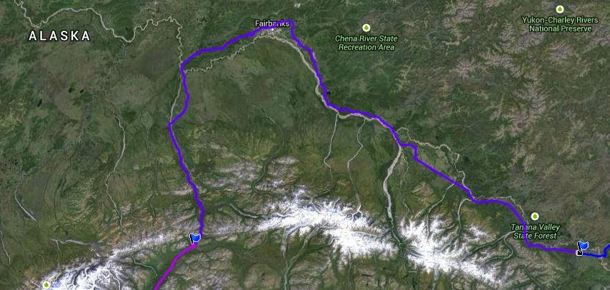
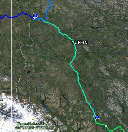
Below is a Draft of the Rout Plan for the 2015 Alaska Adventure, as you can see we cover a lot of ground, so the trip is divided up into Days. We will have both GPS units loaded with the maps routs and way-points and hard copy maps with the rout outlined on it.

As a Note: in 2013 I did not take a GPS but it did print out each days plan with detailed turn by turn directions, I found that after so much planning I actually did not use the Maps or directions on a regular bases, rather I would look at them in the morning and focus on particular destinations, if I got wondered of course (got lost) I could always go back to the map. This year the number of special roads and sights that are just off the main road, that I have planned the GPS just makes sense.  


My Mapping Starts with Google maps, setting way-points as destinations. This helps me plan each days overall mileage and basic rout, I then remap the entire rout in Garmin BaceCamp to create the initial GPS Rout.  Its after this step I go back to Google maps and Google Earth and start looking for those unique roads and sights, I can then go back to BaceCamp and re plan each Day according to the new Plan.
Sounds like a lot of rework, and yes it is, but BaceCamp is the tool I’m using to load my GPS and it is not nearly as up to date or as detailed and Google map and or Earth.
Note: I have found the numbering your way-points in BaceCamp will make the process of creating and modifying routs much easier. I will use a 1 for Day one and .0 - .1 and so on to numerate each way-point for that day, it works for me!
In the End I create Google Map, Google Earth and GPX Files for each person on the trip,  they can load there GPS Print a Map for the family and print one to take along If they would like.

Wednesday, April 8, 2015

ALASKA 2015

ALASKA !
Alaska has a pull no other state has, their seems to be a sense of freedom, a sense of Adventure, its quite a basic feeling coming from ones sole I think.
Thinking of the earliest explorers, of any land, there was this sense of a need to explore, travel and seek new horizons they all had in common.  Early explorers traveled over sea and over vast expanses of land to head this call of adventure to find new land, a fresh start meeting new people and maybe  gain some new hopes and dreams along the way. For them it was a commitment to a new life giving up every security and every sense of a home they and their families may have developed over the years.
Today that commitment to and sacrifice is not the same, but the call is still there, I think adventure is a primal part of every persons sole, though some have a way of pushing it down to suppression and others, like me, cannot resist the temptation to Go…


Alaska is the last frontier, meaning you can still be a settler within the state, you can also walk off in to its wilderness and never return, living off the land and likely never seeing another sole again. Alaska is so large Texas would get lost in its thick woods and glacier filled valleys and you would still have a place so lager you could lose most any states in the union with in its boundaries and never see it.
Adding to the sense of adventure from the US, you must travel through another country to get to Alaska, and for people living in the US that is unique.  Much of Alaska is untouched by Man, and animals live in harmony with the land and most without contact with human, in fact, in most city’s just a few feet outside city limits you are 100% back to nature in all its glory.
For these reasons Alaska is quite unique in its draw to Explorers and Adventure seekers, it’s truly an amazing place!


Why Ride to Alaska? You can definitely Fly in and Ride to all the sights and cut the mileage down and make the trip a Whole Lot easier! I can actually see the reasoning hear, but I just don’t seem to want to do it that way (the majority of people Ride to Alaska rather than Fly in and ride). I think this has to do with the above reasons Plus and this is a big one you would miss out on the ever changing landscape, you would not have the sense of accomplishment and “there is a whole lot to see between here and there. The Biggest reason to Ride may not be so obvious at first, and if you are new to Adventure Travel, I will let you in on a secret, its not just the sights and all this nature! and yes I would do it for that alone but “it’s the people you will meet” as alone as you might think you will get, as remote as you might fill, you’re going to meet some of the most interesting people in the world.

If you are alone they will approach you…  it starts like this - where are you from, where are you headed, how long have you been on the road,  I’ve always dreamed of doing what you are doing.

If they are local they will start pointing you to some of the areas coolest things around and asking if you need anything, if your looking for a place to eat or stay and they will get you pointed in the right direction. If you stay around long enough you are going to learn the history of the areas the person is from and much more.


If they are a fellow traveler it will go more like this, which way are you coming from, how are the roads, was the weather OK, where is the next gas stop. Again stay around long enough and you will get to know them there story and much more. People are so open and so friendly.

If you are traveling with a group, most locals seem to stay clear and wait to see what is happening and most travelers will keep it short, to the first few questions above.


If your with a group it becomes your responsibility to draw out the locals, once you do they will open up, a group is intimidating and as dirty as you will be! you will all look like a bunch of hooligans!

It’s amazing to me when I’m alone or with one other person how many people open up and share there life with me, it is the most amazing thing and is one of the tings keeping me in love with adventure travel.


Book Recommendation:
Travels with Charley (In Search of America) by Mr. John Steinbeck

Sunday, February 22, 2015

Day Thirteen: Cantwell to Anchorage

Cantwell to Anchorage
Today we ride through Denali National Park (Mount McKinley), 

The highest mountain in North America. The park encompasses more than 6 million acres  Locals call in Denali, then in 1886 a gold prospector William Dickey named it Mount McKinley after President William McKinley. Also well to note that the native Athabascan people call the mountain Denali, meaning "The Great One." Out of respect I always try to refer to the area and the great mountain and Denali, as well I don’t realy want to pay homage to the “Dick_ey” who was looking for support from the then president McKinley whom I should note never visited the park, the mountain or Alaska for that matter, its Deali! The mountain is 20,237 feet or (6,168 meters) 83 feet shorter than previously thought (a 1952 measurement)


Tallest Mountain 1,000 feet “taller” than Mount Everest ? how can that be?

There is a distinction between measuring "highest" and "tallest." The highest mountain is determined by measuring a mountain's highest point above sea level. The tallest mountain is measured from base to summit. Using that measurement, Mount McKinley is taller than Mount Everest. McKinley rises about 18,000 feet (5,500 meters) from its base, which is a greater vertical rise than Mount Everest’s 12,000-foot rise (3,700 meters) from its base at 17,000 feet (5,200 meters).


It’s a magnificent ride from the park in to Anchorage, and this ride brings back memories from when I lived here and the exploring I did in my old bronco!


Day Twelve: Tok Fairbanks and on to Cantwell

Tok Fairbanks and on to Cantwell


Looking at the Map closely this looks like one long open road with some snowcapped views off to our right all day. Fairbanks I have never visited so I am looking forward to a quick visit.
Fairbanks is the largest city in the Interior region of Alaska, and third largest in the state, after Anchorage, and Juneau. It is the principal city of the Fairbanks, Alaska, Metropolitan Statistical Area which encompasses all of the Fairbanks North Star Borough and is the northernmost Metropolitan Statistical Area in the United States, lying less than 120 miles (190 km) south of the Arctic.
 Fairbanks 1903
 Fairbanks 1955

 Fairbanks modern day


According to 2012 estimates, the population of the city was 32,070, and the population of the Fairbanks North Star Borough was 100,343
Then on to Cantwell Alaska, it will be a short ride from here to Anchorage where we will meet up with family friends and a new set of tires!
Cantwell got its start as a flag stop for the Alaska Railroad and was named for the nearby Cantwell River. It is located roughly 200 miles from Anchorage and sits just 20 miles outside of Denali National Park and Preserve. This makes it a popular base camp for people wanting to visit Denali and the surrounding areas.

Day Eleven: Dawson City to Tok and don’t forget Chicken!

Dawson City to Tok and don’t forget Chicken!


Today I have been looking forward to for a long time, the “Top of the world Highway”, the highway leads out of Dawson Just after crossing the Yukon River and climbs up the mountain range to the top and stays there all the way to Alaska and your border crossing in to the US.

The Crossing of the Yukon River gives you pause as the mighty river pushes under the ferry, you can see and feel its power as full size trees are flowing with it, looking at the other side you see the ferry struggle to keep ground as cars precariously take to the shore and I say to myself Oh please don’t dump it getting off the ferry.

We ride the mountain tops from here to the boarder where the smooth roads will turn to pothole hell, I feel like the Canadians must have a road crew just out of sight waiting to sweep the road clean as you pass, next customer Please, and thank you, then you get to the US side and they are laying mortars’ every 100 yards as you pass they say dam it lets blow the road up some more we can get the next guy.

It’s a lonely outpost at the border, but its still all business, don’t pull up tell the guy wakes up and turns the light on that says pull forward they are a little pissy about that! In 2013 the guy stood there looking at me finally waved his arm so I moved forward, you would think I stepped on his puppy, he said he was waiting for me to turn my head light off, his waving arm was to tell me to turn off the head light so he could see my license plate? (it’s a motorcycle BTW) any way we were about 5min before the boarder closed, so he likely closed the books and was ready to call it a night when we pulled up.

Chicken is a census-designated place in Southeast Fairbanks Census Area, Alaska, United States. Chicken is a community founded on gold mining and is one of the few surviving gold rush towns in Alaska. The population was 7 in 2010 and in recent years there have become two Chickens, I guess whom ever owned the land next to the highway decided to put up a new town, OK a few buildings, it now sits in front of the original Chicken, which is also made up of just a few buildings and the Chicken poop!

Tok:

The town of Tok began in 1942 as an Alaska Road Commission camp used for construction and maintenance of the Alaska Highway. So much money was spent in the camp's construction and maintenance that it earned the nickname "Million Dollar Camp" from those working on the highway


This photo of Tok, give you a good idea of what it looks like today, the Alaska Highway running through the center gives it the feeling of riding down a runway at your local airport, I actually looked up a few times just in case!

Day Nine and Ten: Dawson City to the Arctic Circle and Back

Dawson City to the Arctic Circle and Back


The Dempster Hwy! “I have a story” back in ? I think it was 7th Grade so excited to get my year book and get the Girl I was so dreamy about to sign my year book and finally see if she liked me… yea I was shy and not super wise about girls. I opened my year book to find my last Name misspelled Christopher Dempster, well today I get to ride the Dempster Highway…I’m not sure how I feel about this…

This part of the trip has the single purpose of getting to an arbitrary line drawn on the map. The Arctic Circle is the southernmost latitude in the Northern Hemisphere at which the sun can remain continuously above or below the horizon for 24 hour (at the June solstice and December solstice respectively) this year that date is June 20th…..YES!

Unlike tens of thousands of years ago relatively few people live north of the Arctic Circle due to the severe climate, I’m hoping we will have good weather over the next two day


Looking at our map, there does not seem to be a lot out this way, so my adventure is all new in this area, I cant wait.

This section has the longest distance (254 mile section) between gas stops even with the GS I need to carry fuel, I can make a comfortable 250 miles on pavement at sea level with good gas, I could likely stretch this to 254 and not break too much of a sweat in economy conditions, but we are not in economy conditions, if we hit rain I will use more fuel, on Dirt I use more fuel, an extra 2 gallons will keep me happy during this part of the trip.

Day Eight: Whitehorse to Dawson City

Whitehorse to Dawson City


Promising to be a spectacular event and a spectacle of motorcycles I was glad to have a reservation for the night hear, it was to be an interesting staying above the Coffee shop down town after all this time out in the wilderness, and with a party raging in to the night I’m suspect sleep may not have been an easy thing to achieve.
Though our original plan was to arrive during this event our plans took an early change and the Ferry from Vancouver island to Prince Rupert did not sail on the day we intended, this would put a three day hold in our plan, we all felt the trip to Vancouver island and the Ferry ride was not to be missed, and seeing so many people, well we could miss that!> this new plan also gave us the extra time on the island we all wanted and took the rush out of the first few day we did not

on my last trip to Dawson in 2013 the fatigue of the ride was starting to set in for me at this point, I was taking on too much distance and much to much time on the bike.
Near the last leg of the trip I end up talking to this girl, a wild-free-spirit traveling gypsy Chick that is just existing on the kindness and generosity of others. I'm thinking holly hell, out hear there is like 50 people in the nearest 1000 miles it must take an eternity to get anywhere Just waiting on a Ride. she did ask for a ride, but I was at capacity, and she could not fit on my bike with all her stuff  walking staff and Dog, hell she was larger than me anyway.

I figured she would have to walk the distance to Dawson City, and was considering how long that was going to take her (needless to say I left with hopes that someday soon she would get a ride)
well........... she made it to Dawson Before me……..what the heck! Not only that she had three friends and they were all set up singing in the park when I arrived! Yikes, did I take a wrong turn, was there a time warp, how did that happen… well maybe traveling on the generosity of others is the fast way to cross the county?

During our travels today you can really tell we are making our way north, trees are smaller and the terrain looks like the weather really takes its toll on things this far north. Tomorrow I hope to make it to the arctic circle,  and that will mark the farthest north I have ever been, at least on the ground! Exciting!