Monday, April 13, 2015

MAPS


 Google Earth, Google Maps and GPS Rout planning can be a daunting Task, though at first glance it seems so simple, “if you want to travel from California to Alaska just put in your start point and end point and it does the work for you” well as it turns out it is a timely process of Picking the sights you want to see and the setting way points on the Roads you would like to ride on the way, A straight line or fastest route is not likely the one you will want to take. After you have selected your rout you will then need to either make legible maps with step by step directions (Google maps will do this part for you quite well) or if you’re taking a GPS you will need to transfer the rout in to a GPS or GPX file for import to you GPS unit.  Its all a time intensive process, but not without its reward, in fact I mention Google earth because if you also open your rout in Google Earth you may find some unexpected treasures!
As you look deeper/closer to each road you have selected you will also see alternate routes that get you to the same place, it is quite common that I find a much better road or an embedded photo left by another user that ultimately has me change my plans for a much better road. Its these little things that can make a good ride in to an epic adventure.
You can get overwhelmed so it’s good to just take one section at a time for the longer trips, and know its well worth the effort in the end.
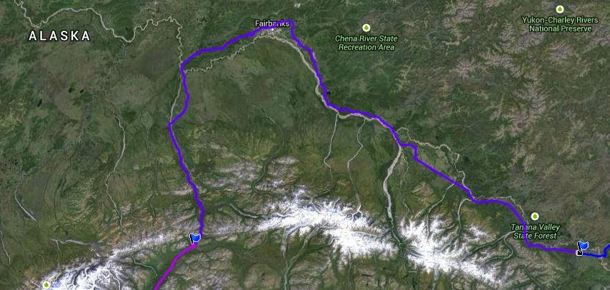
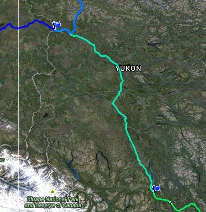
Below is a Draft of the Rout Plan for the 2015 Alaska Adventure, as you can see we cover a lot of ground, so the trip is divided up into Days. We will have both GPS units loaded with the maps routs and way-points and hard copy maps with the rout outlined on it.

As a Note: in 2013 I did not take a GPS but it did print out each days plan with detailed turn by turn directions, I found that after so much planning I actually did not use the Maps or directions on a regular bases, rather I would look at them in the morning and focus on particular destinations, if I got wondered of course (got lost) I could always go back to the map. This year the number of special roads and sights that are just off the main road, that I have planned the GPS just makes sense.  


My Mapping Starts with Google maps, setting way-points as destinations. This helps me plan each days overall mileage and basic rout, I then remap the entire rout in Garmin BaceCamp to create the initial GPS Rout.  Its after this step I go back to Google maps and Google Earth and start looking for those unique roads and sights, I can then go back to BaceCamp and re plan each Day according to the new Plan.
Sounds like a lot of rework, and yes it is, but BaceCamp is the tool I’m using to load my GPS and it is not nearly as up to date or as detailed and Google map and or Earth.
Note: I have found the numbering your way-points in BaceCamp will make the process of creating and modifying routs much easier. I will use a 1 for Day one and .0 - .1 and so on to numerate each way-point for that day, it works for me!
In the End I create Google Map, Google Earth and GPX Files for each person on the trip,  they can load there GPS Print a Map for the family and print one to take along If they would like.

Wednesday, April 8, 2015

ALASKA 2015

ALASKA !
Alaska has a pull no other state has, their seems to be a sense of freedom, a sense of Adventure, its quite a basic feeling coming from ones sole I think.
Thinking of the earliest explorers, of any land, there was this sense of a need to explore, travel and seek new horizons they all had in common.  Early explorers traveled over sea and over vast expanses of land to head this call of adventure to find new land, a fresh start meeting new people and maybe  gain some new hopes and dreams along the way. For them it was a commitment to a new life giving up every security and every sense of a home they and their families may have developed over the years.
Today that commitment to and sacrifice is not the same, but the call is still there, I think adventure is a primal part of every persons sole, though some have a way of pushing it down to suppression and others, like me, cannot resist the temptation to Go…


Alaska is the last frontier, meaning you can still be a settler within the state, you can also walk off in to its wilderness and never return, living off the land and likely never seeing another sole again. Alaska is so large Texas would get lost in its thick woods and glacier filled valleys and you would still have a place so lager you could lose most any states in the union with in its boundaries and never see it.
Adding to the sense of adventure from the US, you must travel through another country to get to Alaska, and for people living in the US that is unique.  Much of Alaska is untouched by Man, and animals live in harmony with the land and most without contact with human, in fact, in most city’s just a few feet outside city limits you are 100% back to nature in all its glory.
For these reasons Alaska is quite unique in its draw to Explorers and Adventure seekers, it’s truly an amazing place!


Why Ride to Alaska? You can definitely Fly in and Ride to all the sights and cut the mileage down and make the trip a Whole Lot easier! I can actually see the reasoning hear, but I just don’t seem to want to do it that way (the majority of people Ride to Alaska rather than Fly in and ride). I think this has to do with the above reasons Plus and this is a big one you would miss out on the ever changing landscape, you would not have the sense of accomplishment and “there is a whole lot to see between here and there. The Biggest reason to Ride may not be so obvious at first, and if you are new to Adventure Travel, I will let you in on a secret, its not just the sights and all this nature! and yes I would do it for that alone but “it’s the people you will meet” as alone as you might think you will get, as remote as you might fill, you’re going to meet some of the most interesting people in the world.

If you are alone they will approach you…  it starts like this - where are you from, where are you headed, how long have you been on the road,  I’ve always dreamed of doing what you are doing.

If they are local they will start pointing you to some of the areas coolest things around and asking if you need anything, if your looking for a place to eat or stay and they will get you pointed in the right direction. If you stay around long enough you are going to learn the history of the areas the person is from and much more.


If they are a fellow traveler it will go more like this, which way are you coming from, how are the roads, was the weather OK, where is the next gas stop. Again stay around long enough and you will get to know them there story and much more. People are so open and so friendly.

If you are traveling with a group, most locals seem to stay clear and wait to see what is happening and most travelers will keep it short, to the first few questions above.


If your with a group it becomes your responsibility to draw out the locals, once you do they will open up, a group is intimidating and as dirty as you will be! you will all look like a bunch of hooligans!

It’s amazing to me when I’m alone or with one other person how many people open up and share there life with me, it is the most amazing thing and is one of the tings keeping me in love with adventure travel.


Book Recommendation:
Travels with Charley (In Search of America) by Mr. John Steinbeck

Sunday, February 22, 2015

Day Thirteen: Cantwell to Anchorage

Cantwell to Anchorage
Today we ride through Denali National Park (Mount McKinley), 

The highest mountain in North America. The park encompasses more than 6 million acres  Locals call in Denali, then in 1886 a gold prospector William Dickey named it Mount McKinley after President William McKinley. Also well to note that the native Athabascan people call the mountain Denali, meaning "The Great One." Out of respect I always try to refer to the area and the great mountain and Denali, as well I don’t realy want to pay homage to the “Dick_ey” who was looking for support from the then president McKinley whom I should note never visited the park, the mountain or Alaska for that matter, its Deali! The mountain is 20,237 feet or (6,168 meters) 83 feet shorter than previously thought (a 1952 measurement)


Tallest Mountain 1,000 feet “taller” than Mount Everest ? how can that be?

There is a distinction between measuring "highest" and "tallest." The highest mountain is determined by measuring a mountain's highest point above sea level. The tallest mountain is measured from base to summit. Using that measurement, Mount McKinley is taller than Mount Everest. McKinley rises about 18,000 feet (5,500 meters) from its base, which is a greater vertical rise than Mount Everest’s 12,000-foot rise (3,700 meters) from its base at 17,000 feet (5,200 meters).


It’s a magnificent ride from the park in to Anchorage, and this ride brings back memories from when I lived here and the exploring I did in my old bronco!


Day Twelve: Tok Fairbanks and on to Cantwell

Tok Fairbanks and on to Cantwell


Looking at the Map closely this looks like one long open road with some snowcapped views off to our right all day. Fairbanks I have never visited so I am looking forward to a quick visit.
Fairbanks is the largest city in the Interior region of Alaska, and third largest in the state, after Anchorage, and Juneau. It is the principal city of the Fairbanks, Alaska, Metropolitan Statistical Area which encompasses all of the Fairbanks North Star Borough and is the northernmost Metropolitan Statistical Area in the United States, lying less than 120 miles (190 km) south of the Arctic.
 Fairbanks 1903
 Fairbanks 1955

 Fairbanks modern day


According to 2012 estimates, the population of the city was 32,070, and the population of the Fairbanks North Star Borough was 100,343
Then on to Cantwell Alaska, it will be a short ride from here to Anchorage where we will meet up with family friends and a new set of tires!
Cantwell got its start as a flag stop for the Alaska Railroad and was named for the nearby Cantwell River. It is located roughly 200 miles from Anchorage and sits just 20 miles outside of Denali National Park and Preserve. This makes it a popular base camp for people wanting to visit Denali and the surrounding areas.

Day Eleven: Dawson City to Tok and don’t forget Chicken!

Dawson City to Tok and don’t forget Chicken!


Today I have been looking forward to for a long time, the “Top of the world Highway”, the highway leads out of Dawson Just after crossing the Yukon River and climbs up the mountain range to the top and stays there all the way to Alaska and your border crossing in to the US.

The Crossing of the Yukon River gives you pause as the mighty river pushes under the ferry, you can see and feel its power as full size trees are flowing with it, looking at the other side you see the ferry struggle to keep ground as cars precariously take to the shore and I say to myself Oh please don’t dump it getting off the ferry.

We ride the mountain tops from here to the boarder where the smooth roads will turn to pothole hell, I feel like the Canadians must have a road crew just out of sight waiting to sweep the road clean as you pass, next customer Please, and thank you, then you get to the US side and they are laying mortars’ every 100 yards as you pass they say dam it lets blow the road up some more we can get the next guy.

It’s a lonely outpost at the border, but its still all business, don’t pull up tell the guy wakes up and turns the light on that says pull forward they are a little pissy about that! In 2013 the guy stood there looking at me finally waved his arm so I moved forward, you would think I stepped on his puppy, he said he was waiting for me to turn my head light off, his waving arm was to tell me to turn off the head light so he could see my license plate? (it’s a motorcycle BTW) any way we were about 5min before the boarder closed, so he likely closed the books and was ready to call it a night when we pulled up.

Chicken is a census-designated place in Southeast Fairbanks Census Area, Alaska, United States. Chicken is a community founded on gold mining and is one of the few surviving gold rush towns in Alaska. The population was 7 in 2010 and in recent years there have become two Chickens, I guess whom ever owned the land next to the highway decided to put up a new town, OK a few buildings, it now sits in front of the original Chicken, which is also made up of just a few buildings and the Chicken poop!

Tok:

The town of Tok began in 1942 as an Alaska Road Commission camp used for construction and maintenance of the Alaska Highway. So much money was spent in the camp's construction and maintenance that it earned the nickname "Million Dollar Camp" from those working on the highway


This photo of Tok, give you a good idea of what it looks like today, the Alaska Highway running through the center gives it the feeling of riding down a runway at your local airport, I actually looked up a few times just in case!

Day Nine and Ten: Dawson City to the Arctic Circle and Back

Dawson City to the Arctic Circle and Back


The Dempster Hwy! “I have a story” back in ? I think it was 7th Grade so excited to get my year book and get the Girl I was so dreamy about to sign my year book and finally see if she liked me… yea I was shy and not super wise about girls. I opened my year book to find my last Name misspelled Christopher Dempster, well today I get to ride the Dempster Highway…I’m not sure how I feel about this…

This part of the trip has the single purpose of getting to an arbitrary line drawn on the map. The Arctic Circle is the southernmost latitude in the Northern Hemisphere at which the sun can remain continuously above or below the horizon for 24 hour (at the June solstice and December solstice respectively) this year that date is June 20th…..YES!

Unlike tens of thousands of years ago relatively few people live north of the Arctic Circle due to the severe climate, I’m hoping we will have good weather over the next two day


Looking at our map, there does not seem to be a lot out this way, so my adventure is all new in this area, I cant wait.

This section has the longest distance (254 mile section) between gas stops even with the GS I need to carry fuel, I can make a comfortable 250 miles on pavement at sea level with good gas, I could likely stretch this to 254 and not break too much of a sweat in economy conditions, but we are not in economy conditions, if we hit rain I will use more fuel, on Dirt I use more fuel, an extra 2 gallons will keep me happy during this part of the trip.

Day Eight: Whitehorse to Dawson City

Whitehorse to Dawson City


Promising to be a spectacular event and a spectacle of motorcycles I was glad to have a reservation for the night hear, it was to be an interesting staying above the Coffee shop down town after all this time out in the wilderness, and with a party raging in to the night I’m suspect sleep may not have been an easy thing to achieve.
Though our original plan was to arrive during this event our plans took an early change and the Ferry from Vancouver island to Prince Rupert did not sail on the day we intended, this would put a three day hold in our plan, we all felt the trip to Vancouver island and the Ferry ride was not to be missed, and seeing so many people, well we could miss that!> this new plan also gave us the extra time on the island we all wanted and took the rush out of the first few day we did not

on my last trip to Dawson in 2013 the fatigue of the ride was starting to set in for me at this point, I was taking on too much distance and much to much time on the bike.
Near the last leg of the trip I end up talking to this girl, a wild-free-spirit traveling gypsy Chick that is just existing on the kindness and generosity of others. I'm thinking holly hell, out hear there is like 50 people in the nearest 1000 miles it must take an eternity to get anywhere Just waiting on a Ride. she did ask for a ride, but I was at capacity, and she could not fit on my bike with all her stuff  walking staff and Dog, hell she was larger than me anyway.

I figured she would have to walk the distance to Dawson City, and was considering how long that was going to take her (needless to say I left with hopes that someday soon she would get a ride)
well........... she made it to Dawson Before me……..what the heck! Not only that she had three friends and they were all set up singing in the park when I arrived! Yikes, did I take a wrong turn, was there a time warp, how did that happen… well maybe traveling on the generosity of others is the fast way to cross the county?

During our travels today you can really tell we are making our way north, trees are smaller and the terrain looks like the weather really takes its toll on things this far north. Tomorrow I hope to make it to the arctic circle,  and that will mark the farthest north I have ever been, at least on the ground! Exciting!

Day Seven: Watson Lake to the City of Whitehorse

Watson Lake to the City of Whitehorse

Today we are out on the Alaska Highway and the feel of a large freeway returns, giving me the feeling of being back in the states (lower 48 of the united states) this means dealing with More RV’s larger trucks and fast moving traffic, I actually get the feeling hear I missed something, lake we passed out of the wilderness, in reality we are now in the Vast Yukon Territory and as far from any large metropolitan area as we have been, looking at the map and wow and I’m reconnected with reality we are in the middle of it now, and though this larger roadway my give one the feeling of security we are in the greater outreaches of the world now, this adventure can go in any direction. It is a good time to reflect and take inventory of my attitude, the hard part is yet to come and our metal may be tested from here on out.
As we move north we slide back in to British Colombia and then back out to the Yokon, then the progression seems to take us steeper north before reaching west then north again, these are large stretches of road but my sense of direction seems tuned in to where we need to go and I feel like Alaska is some ware over these peaks, stopping and looking at the map, Alaska is a long, long way off but at least the direction is right, though we will travel much farther north before reaching out to Alaska it again reminds me we are just getting in to the swing of the trip.
Whitehorse is an interesting place and there is much to see, though on my last trip I saw no more than the camp site I stayed in and the gas station I field up in, (same gas station both direction), I think I was way too focused on the days distance and what was coming next, I must digress a bit,  but this tends to be a common problem with trips like this, we look forward to our next destination and the road we need to travel to get there, as in life we need to keep in mind “the adventure is hear, in the moment we are in, we are living it! When we do get to the next destination that then will be our adventure at that moment”. I am constantly reminded to live in the now.

On my last trip I stayed at the Robert Service Campground, a bit of a hippy commune, and at first the high price and all the people was a bit too much for me to handle at the time, I eventually settled in or accepted it, but I’m just not sure what I should do this trip. 

Day Six: Hyder AK to Watson Lake

Hyder AK to Watson Lake

Passing Dease Lake and then Simmons Like and Vines Lake you feel as if you found the longest lakes in the world, they just keeps going and going and going, it’s amazing! Again I find myself thinking I would like to stay a while and explore…so many places to explore so little time.

Today we will finish the Stuart Cassiar Hwy and head up the Alaska Hwy to Watson Lake and the Signpost Forest. Its worth a note, in 2013 I rode the Cassiar on the way up and the Alaska Hwy on the way back, and though you hear people talking about the challenge of the Cassiar Vs the easy rout of the Alaska Hwy, on my trip I felt the Alaska Hwy was more of a challenge in terms of fatigue and the risk of other drivers colliding with you. Also on the Cassiar you feel like you’re on an adventure whereas on the Alaska Hwy highway your just part of the crowds headed North or South. I like the intimate experience of the Cassiar, I plan to ride this on the way back this time as well.


Day Five: Prince Rupert to Hyder AK

Prince Rupert to Hyder AK


Prince Rupert's sheltered harbour is the deepest ice-free natural harbour in North America, and the 3rd deepest natural harbour in the world ranging from 34 to 44 meters. We will move on from here to Meziadin Lake, one of the many Lakes that seem to go on forever, and with amazing shorelines I feel like we could stay and explore areas like these for a week at a time, so beautiful!


Next we head to through Stewart to Hyder, in 2013 I stopped at the junction of 37 and 37A the Glacier Hwy wondering what I am going to miss not going to Hyder,  Im glad to be traveling this way today. A little history, In 2013 I was Traveling with live long friend Tim, and as we approached this intersection we were introduced to the Mobile Gas Station outposts, (you have to apply right there on the spot, take a test and “pass” then get approved for an authorization code so that you can operate the pump, its all automated and there is no attendant or phone number to call if it does not work, well Tim was denied “Oh SiHt) well after that expereance we thought it best to keep to plan and work our way north. Well not this trip we want to see this area!
Hyder was established in 1907 as Portland City, after the canal.[3] In 1914, when the US Post Office Department told residents that there were many U.S. communities named Portland, it was renamed Hyder, after Frederick Hyder, a Canadian mining engineer who envisioned a bright future for the area. Hyder was the only practical point of access to the silver mines in Canada; the community became the port, supply point, and post office for miners by 1917. Hyder's boom years were the 1920s, when the Riverside Mine on the U.S. side extracted gold, silver, copper, lead, zinc, and tungsten. The mine operated from 1924 to 1950.

It’s not a largely populated Place!


Day Four: Ferry Ride to Price Rupert (the inside passage)

The inside passage

Deadlines and Schedules Oh-my, to this point and after this point Schedules are Just a guide more than the rule, today our Schedule is really marking a deadline we need to meet, I’m actually nervous I will miss the ship and nervous about securing my bike so it does not fall over, as well I have a fear someone’s car is going to roll around at run over my bike…


This leg of the trip will involve vary little riding but still take about 16 hours starting at 7:30am and arriving at 11:30PM, it’s going to be a long day..


This is, in reverse part of the trip I had planned for my 2013 trip, but at the time I just could not see myself riding on a ferry rather than riding my motorcycle. My plan then was to ride a three day Ferry down and experiencing the full inside passage and the camaraderie that goes with it, I had visions of a Hippie tent town aboard a ship cursing down and amazing labyrinth of mountains and sea, then jumping on my bike and riding only two more days home, it was just too much to think my trip would be over like that so I rode the solo trip and had the time of my life.

This time the risk is small, I will not miss any part of the ride, in fact on the return trip I will ride the missing portion taken by the ferry on the way up, I’m adding an important piece missing from road travel and experiencing something new, I just need to find something to do for 16hrs.

Day Three: Aberdeen WA to Vancouver Island BC

Aberdeen WA to Vancouver Island BC


So much to see so little time, this area (Olympic National Forest) has long been on my list of places to explore, With an area of 628,115 acres (2,541.89 km2), it nearly surrounds Olympic National Park and the Olympic Mountain range. Olympic National Forest contains parts of Clallam, Grays Harbor, Jefferson, and Mason counties. The landscape of the national forest varies, from the temperate Olympic rain forest to the salt water fjord of Hood Canal to the peaks of Mt. Washington.
And though I have explored the west side of these mountains and other areas of Washington this area with its vast rain forest would be a great place to spend time exploring, but we are on the bikes and need to get to the ferry at Port Angeles and on to Vancouver Island.
 Vancouver Island sits South of the 49th Parallel and It has the warmest climate in the country (British Columbia) and since the mid-1990s has been mild enough in a few areas to grow subtropical Mediterranean crops such as olives and lemons.  We can expect larger climate changes the farther north we get, I won’t expect vast orange crops or plantations of Pineapple any more.

In 1792, the Spanish explorer Dionisio Alcalá Galiano and his crew were the first Europeans to circumnavigate Vancouver Island. On April 8, 1806, Captain John D'Wolf ofBristol, Rhode Island sailed the Juno to Newettee, a small inlet in the northwestern promontory of Vancouver's Island. 

in 1846, the Oregon Treaty was signed by the British and the U.S. to settle the question of the U.S. Oregon Territory borders. It awarded all of Vancouver Island to Britain, despite a portion of the island lying south of the 49th parallel. 
Our first stop after boarding the ferry will be Victoria, British Columbia. In this harbor you feel as if you have just completed a long gurney to a distant land, well a new country yes but not far from the US and the world seems to have changed.


We have one day to explore the island and we are expected on our next ferry ride from Port Hardy to Price Rupert.

Day Two: Oregon to Aberdeen Washington

Oregon to Aberdeen Washington


We will Ride lots of Coast line today and see lots of Beach, rocky steep and beautiful.
Coos Bay is a quaint little town….no wait change that this is the largest city on the Oregon Coast! Well it just seems small and quaint; I can see that my perception needs to change as I ride north;
I am now reminded of a trip I took in 1989 I was on a KLR 650 and my friend also Chris was on an XT500 we were on our first real bike adventure and we thought no better way to ride up the cost than to ride the sand dunes of the Oregon coast, we started just north of here in Lakeside, and we spent the next 2hrs riding about 100 yards of sand and heading back to the pavement! Needless to say they sank like a rock on water, well at least the KLR did, Chris had a bit better luck with the XT but we learned quick you need to ride the hard pack near the water to get anywhere fast.


Next up is Florence: This is a great stop for any traveler, turn Right after the bridge and head down to the wharf, great food and shops on Bay Street.

How did Florence get its name, I know you did not ask, but there is a story hear and if you find an old-timer you can have one long debate of how the mane was derived, Here is what I know:
A sailing vessel named Florence wrecked along the Oregon Coast near Florence on November 18, 1875. In the wreckage the wooden Name Plate from the boat was found and a man named Thomas Safly nailed this wooden board (the ship’s nameplate) over the door of the hotel in downtown Florence that also served as the post office. “With that, Florence became the name of the town.” The better stories are told of the native people of the land and how they came up with the name, just ask someone to explain!
We will also Pass Newport, Lincoln City and of course Tillamook, if you have time and are in the mood for a real tourist trap/stop you can take the Tillamook tour, Tillamook does have good cheese and as you might expect are really in the dairy business to make all that cheese.

Now we move on, past Rockaway Beach? 
Wait! This is not Long Island in New York? Well that where they got the name in 1911 (it was named “Rockaway” and was connected by train to Portland in 1912, and in 1987 they changed the name to Rockaway Beach just like New York, well not really! But hay they did invent the Pronto Pup?! A brand of corn Dog in the late 1930’s..ok moving on! And we really need to make some ground!
Seaside is next and on to Astoria where The Lewis and Clark Expedition spent the winter of 1805–1806 at Fort Clatsop, a small log structure south and west of modern-day Astoria. The expedition had hoped a ship would come by to take them back east, but instead endured a torturous winter of rain and cold, then returned east the way they came. Today the fort has been recreated and is now a historical park.


We move on cross another State Line and are in Aberdeen Washington.
Aberdeen was named for a local salmon cannery to reflect its Scottish fishing port namesake of Aberdeen and because it too is also situated at the mouth of two rivers just like its namesake in Scotland which is located between the rivers 'Don' at the north and the river 'Dee' to the south side of the Scottish city.


Day One: California to Oregon

California to Oregon

My day of departure for the 2015 Alaska Adventure is finally hear, as you may have already read, this trip is quite a bit different from 2013 and starting today the difference will be felt.

As I look back at 2013, all I could think about on this day was mileage, how many miles can I do in one day, well I did 700 Miles on California interstate 5, and had to endure 113 degree heat for much of the day… ouch!

This time the trip takes me directly to the Coast Highway 1 by way of San Francisco the over the New bay Bridge and the nostalgic Golden Gate.
The Bay Bridge was finished on November 12th 1936 allowing for easier passage to San Francisco from the East Bay; the new span we cross today was completed and open to the public on September 2, 2013 it is a more elegant passage and the Views will be even better once the Old Span has been completely removed!


A short ride through San Francisco and we cross the Golden Gate, opened on May 27th 1937 this bridge brought quick access to the City from the north Bay, but more so it now stood as a symbol of magnificence to all who crossed under it by sea! The gate way to the gold country now had an iconic symbol to stand tall.


Just a bit of Trivia only 11 construction workers lost their lives building the golden gate, but 28 died building the Bay Bridge (they just don’t talk about that as much) there were no deaths associated with the building of the new span!


 From hear we take California highway 1 to 101 through Santa Rosa, and up to Cloverdale once known as Markleville, as part of a Mexican Grant in 1865 and was incorporated in 1872 when the Pacific Railroad arrived in 1872, as it turns out the tribes that inhabited this land were illegally displaced and in 1979 a Pomo woman finally filed a class action lawsuit returning the land to the original owners as of 1983 (or their descendants) but in 1994 the feds took it back with a land use grant to put a freeway (the highway 101 bypass) right through the tribal land and the land was lost for good.
We will take the 101 Bypass and link to Highway 128 and over to Highway 1 and follow the California Coast to Oregon.
I would be remiss not to mention the Navarro Winery on Highway 128, some Great wine and a nice place to stop and relax!


The history up the coast is grand, and Places like Mendocino, Noyo Bay, Fort Bragg, farther up to WestPort and finally connecting back to 101 at Leggett
Your next Must see is Avenue of the Giants (highway 254), where you will be both impressed and quite shocked at the sight of Large Redwood trees and the mass destruction people have had on the area, the Massive trees we see today are just a small sample of the giants that stood hear a hundred years ago, it’s hard to imagine these are small trees. The ride is well worth the time and is a must to for a motorcycle traveler in this area.
We will hit the coast again in Eureka and push our way up through Crescent city and across the state line in to Oregon and in to Brookings.
Brookings, named after John E. Brookings, president of the Brookings Lumber and Box Company, which founded the city in 1908
Brookings, became the first site in the continental United States to suffer aerial bombardment in wartime the date was September 9th 1942. A Japanese floatplane piloted by Nobuo Fujita launched from submarine I-25 was loaded with incendiary bombs and sent to start massive fires in the dense forests of the Pacific Northwest, The attack caused only minor damage.

 Fujita was invited back to Brookings in 1962 and he presented the town his family's 400-year-old samurai sword in friendship after the Japanese government was given assurances that he would not be tried as a war criminal. Brookings made him an honorary citizen several days before his death in 1997.